Service Results
CleanSeaNet provides end-users with more than 3,000 satellite images per year and is integrated into national oil spill response chains supplementing the existing surveillance systems at national or regional level, strengthening Member State responses to illegal discharges, and supporting response to accidental spills.
The deterrent effect of the satellite-based oil spill monitoring service is clear: over most of the past decade the overall trend has been a year-on-year reduction in the number of possible oil spills detected per million sq. km monitored. The increase in awareness of maritime pollution is visible since the beginning of the service; not only maritime laws are stricter, but there is also a significant improvement of national authorities’ action capabilities towards polluters.
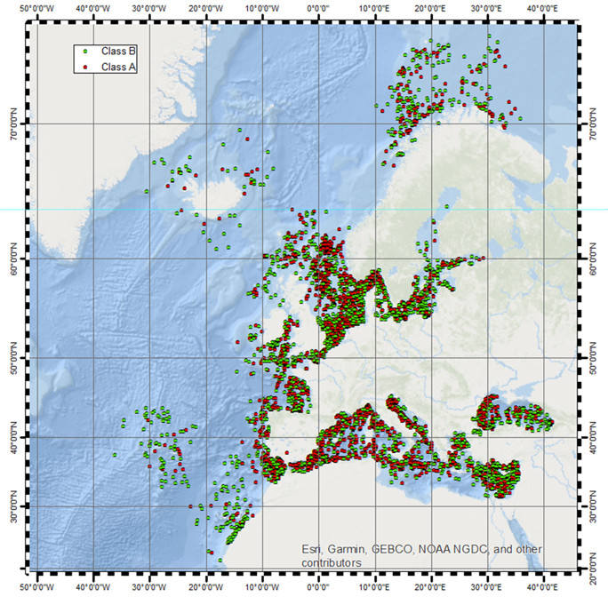 2018 CleanSeaNet detection statistics: dots in the map represent the spills which have a higher detection confidence level (in red) and a lower detection confidence level (in green).
As CleanSeaNet is linked to national and regional response chains, interaction with user communities in the coastal States is important for ensuring the best use of the service and identifying improvements to be made. CleanSeaNet User Group meetings are organised regularly by EMSA. These events are an opportunity to foster better communication with authorities using CleanSeaNet in the coastal states and get feedback on the user requirements, and on weaknesses and strengths of the service from their perspective. The Agency also provides regular trainings at EMSA’s premises or on-site.
Related Documents
- CleanSeaNet - Detections and Feedback data (2015-2022)
- CleanSeaNet Services Catalogue (2023)
- Earth Observation services infosheet - Supporting Rescue Coordination Centres
- CleanSeaNet - European satellite based oil spill monitoring and vessel detection service
- Copernicus Maritime Surveillance - Product Catalogue
- CleanSeaNet Service - Detecting Marine Pollution from Space
- Copernicus Maritime Surveillance - Info sheets
- Copernicus Maritime Surveillance - Service Overview
- Automatic Detection and Alert Triggering of Ship Behaviour [leaflet]
- Celebrating the CleanSeaNet Service. A ten year anniversary publication
- Integrated Maritime Policy and the SafeSeaNet Ecosystem
- The CleanSeaNet service
- Addressing Illegal Discharges in the Marine Environment
- Integrated Maritime Service Brochure
- CleanSeaNet First Generation Report
- Using satellites to improve maritime safety and combat marine pollution [leaflet]
- EMSA view on the GMES programme of EU and ESA
- CleanSeaNet [2007 leaflet]